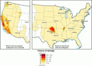
The United States Geological Survey (USGS) forecast for 2017 says Oklahoma will face earthquake damage risk equal to California. The report is close to last year’s forecast which indicates a trend that is changing the region. The 2017 hazard model is the same as the 2016 report but includes an updated earthquake catalog. The 2016 forecast indicated a high hazard (greater than 1%) for Oklahoma-Kansas, the Raton basin (Colorado/New Mexico border) north Texas, north Arkansas, and the New Madrid seismic zone.
Experts believe hydraulic fracturing or fracking is responsible. Fracking involves injecting water and other chemicals at high pressure into the Earth to extract hydrocarbon resources.
The changes in the area are a reminder to risk managers that tornado is not the only major hazard. A Business Impact Analysis (BIA) is the first step in developing a complete Business Continuity Plan (BCP) that will prepare your small business for natural and manmade disasters. Our services team can provide BCP training and implementation to your company. Contact us today for a consultation.